Understanding Our Development Application: A Community FAQ
We recently lodged a Development Application with the City of Gold Coast. The proposal builds upon an existing approval and seeks to deliver a thoughtfully planned neighbourhood that responds to the site’s natural features, environmental values, and surrounding area.
We recognise that development proposals can raise questions for nearby residents and the broader community. This page has been prepared to clearly explain what is proposed, how the land will be developed, and the key considerations.
For those who wish to review the formal application documents, information regarding our current application can be found on the City of Gold Coast PD Online portal by searching for ROL/2025/95.
If you have further questions after reviewing the information below, we welcome you to contact us directly.
Frequently Asked Questions
1. What is the development proposal?
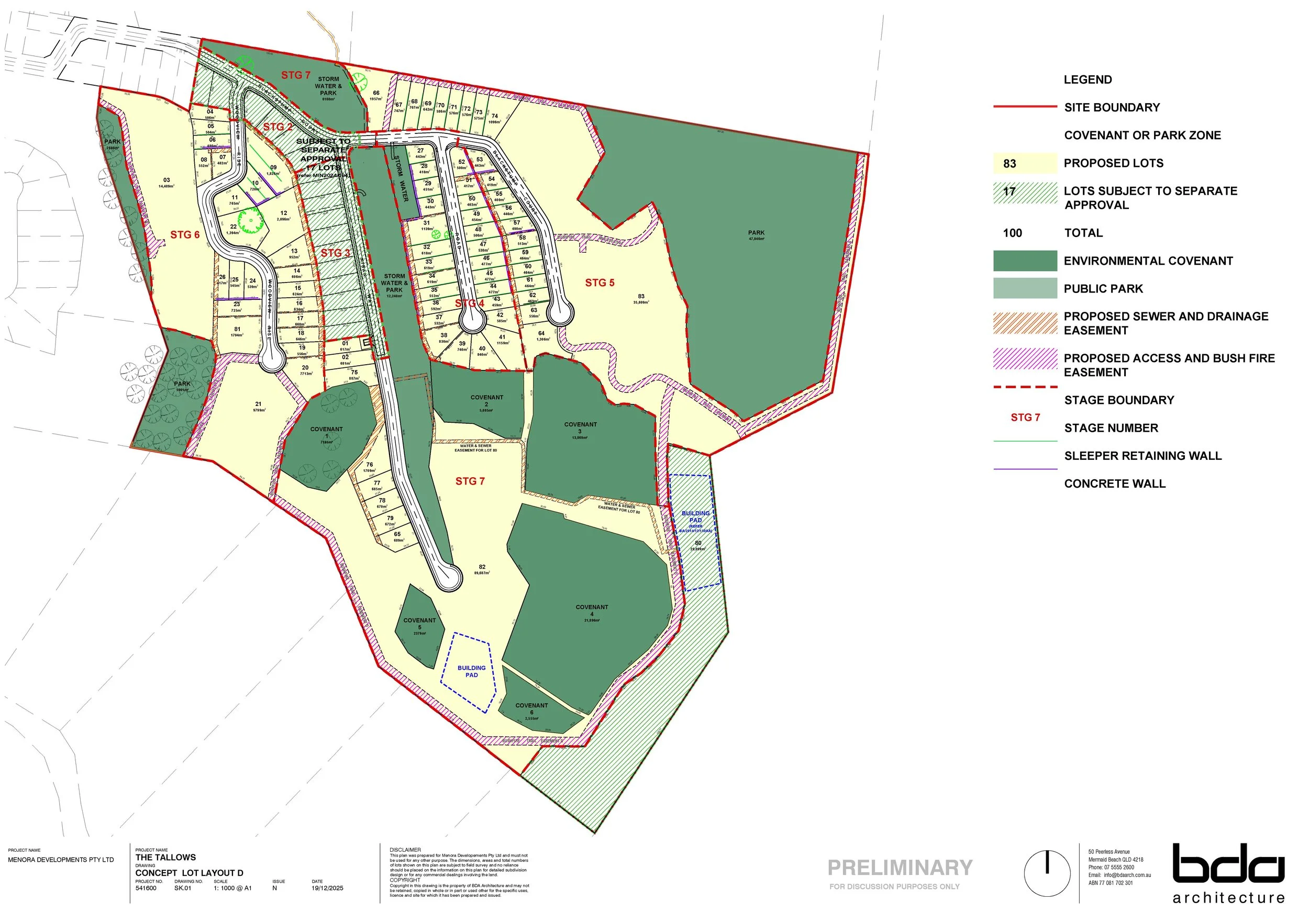
We have lodged a development application for 83 residential lots, bringing the total number of lots on the overall parcel to 100. Seventeen residential lots are already approved under an existing development approval (Council reference: MIN/2024/594).
The proposal seeks to establish a contemporary suburban neighbourhood, intended to be delivered in a series of stages.
2. What are the lot sizes?
The proposal includes a mix of residential allotments intended to accommodate single-family detached homes. A diverse range of lot sizes are proposed, ranging from large acreage parcels of up to 44,580 m² to more traditional suburban lots ranging from 1,845m² down to 400m².
Each lot is suitably configured to ensure it can practically accommodate a modern family home.
3. What is the current zoning for the land?
The site is identified within the Emerging Community Zone under the City of Gold Coast City Plan. This zone is intended to support the development of new communities.
The subject site represents one of the few remaining greenfield development opportunities in the City, and its development will make a meaningful contribution to the supply of much-needed housing.
4. Will there be tree clearing?
No. All remaining trees on the site are protected and will either:
be dedicated as conservation parkland to Council, or
be protected under environmental covenants registered on title.
No additional vegetation clearing is proposed.
5. What environmental protections are included?
The development includes substantial areas (32% site coverage) set aside solely for environmental protection:
5.64 hectares dedicated as Conservation Park, and
5.219 hectares protected under Environmental Covenants.
In addition, the design incorporates landscaped stormwater management areas across the site to improve water quality and protect downstream environments.
5. Will there be traffic impacts to the local area?
Traffic engineering advice confirms that the local road network has sufficient capacity to accommodate the proposed development, without the requirement for any upgrades or modifications.
6. How is stormwater managed?
Stormwater runoff will be directed to a central drainage reserve incorporating a series of detention basins and bioretention systems. This integrated approach will effectively manage both stormwater quantity and quality in accordance with the requirements of the City of Gold Coast City Plan. The centralised reserve will also be landscaped, creating an attractive, vegetated feature within the development.
7. Local recreational park?
Preliminary investigations found that the site’s steep topography makes it impractical to deliver a functional, accessible park that complies with City Plan SC6.12 without extensive earthworks and retaining structures. Such works would reduce usability and create long-term maintenance issues. The site is already well serviced by nearby parks, which are appropriately located and capable of meeting future residents’ recreational needs. As a result, including a park within the subdivision would offer little additional benefit and would instead create an unnecessary maintenance burden.
8. Water & sewer capacity?
The proposal’s water connection strategy involves connecting to the existing 150 mm water main in Blackstump Court and establishing an additional connection via a new water reticulation system linked to the Marriott Way Reservoir, currently under construction as part of the adjoining Skyridge development (OPW/2024/894). All lots will be able to connect to Council’s reticulated gravity sewer network. Easements required for water and sewer infrastructure have been identified on the Plan of Subdivision where necessary.
9. Retaining walls?
Retaining walls have been designed as tiered structures and are located entirely within private allotments, consistent with City Plan requirements. It is expected that Council will impose conditions relating to the materials and finishes used for retaining walls visible from the public realm, to ensure they present as visually appealing elements that contribute positively to the streetscape.
10. Road gradients?
The proposal includes the delivery of several public roads, which will be constructed in accordance with the relevant design criteria, including achieving appropriate gradients. All lots will maintain a maximum gradient of 16%, consistent with the City Plan Land Development Guidelines.
If you have any further queries, please email us at info@thetallows.com.au
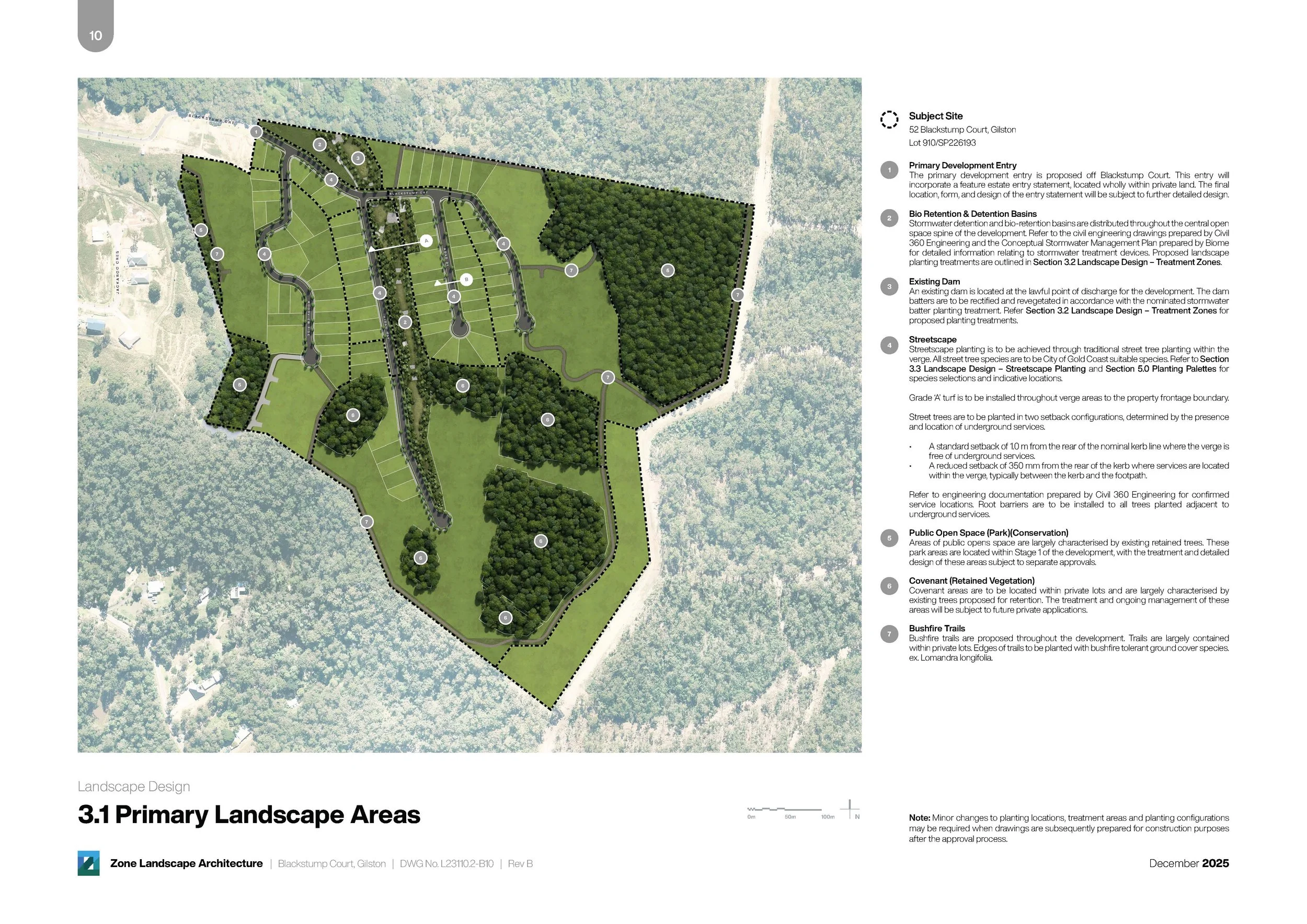
As part of our development application for the Gilston residential estate, the landscape architect prepared a primary landscape area plan showing future open space, planting, and environmental buffers.